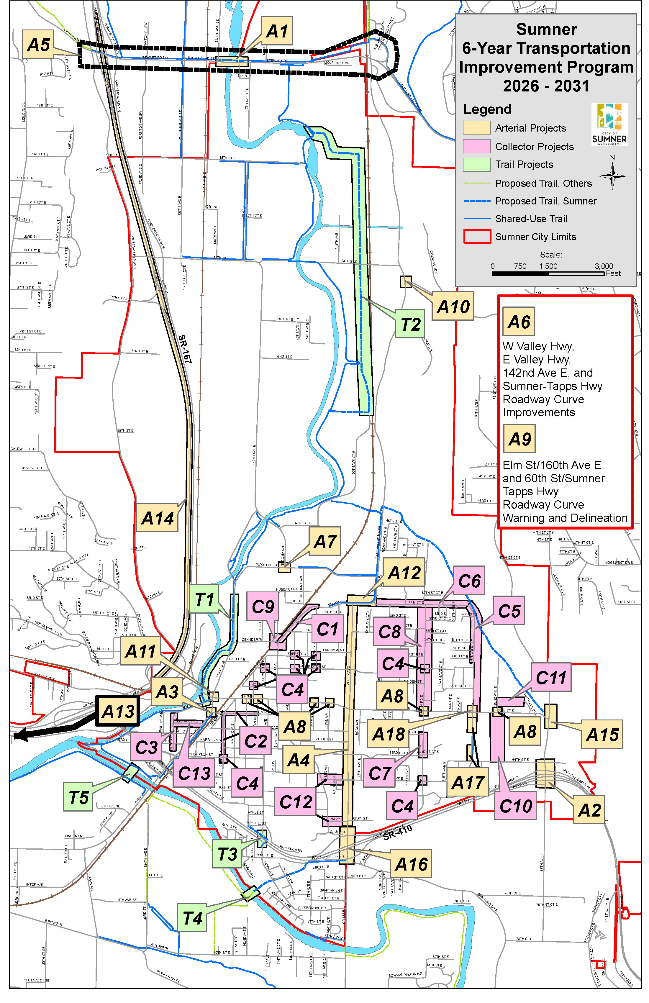
Arterials
A1 – Stewart Rd (8th St.) White River Bridge
Replace existing 2-lane bridge with new bridge with two unequal length spans. New structure will accommodate 4 vehicle lanes, a sidewalk, and a trail crossing.
- Click here for full project page
- Location: Stewart Road at White River
- Total Cost: $35,000,000
- Funded: Yes
- Planning: Complete
- Design: Complete
- ROW/Permit: Complete
- Construction: 2025-2028
- Remarks: Project funded by Federal STP Grant, FMSIB Grant, Pierce County, Port of Tacoma, TIB, Congressional Allocation, NHFP and City of Auburn.
A2 – 166th Ave E Widening
Widen 166th Ave E to 4-5 lanes through the identified corridor and improve lane configuration and dual roundabouts at the two existing intersections.
- Click here for the full project page.
- Location: SR 410 WB Ramp Terminals to just north of 64th St. E.
- Total Cost: $18,000,000
- Funded: Partial
- Planning: Complete
- Design: 2027
- ROW/Permit: 2027
- Construction: 2028-2030
- Remarks: Design is City funded, received a Port of Tacoma Grant and a federal STP grant. Received a federal STP grant for the ROW phase.
A3 – Maple Street Pedestrian Signal and Citywide Signal Backplates
Replace existing pedestrian-activated rectangular rapid flashing beacons with signal (expected to be a High Intensity Activated Crosswalk (HAWK) signal), add retroreflective backplates to upgrade signal heads citywide.
- Location: Traffic Avenue and Maple Street Ped Signal, Backplates Various Locations Citywide
- Total Cost: $431,000
- Funded: Yes
- Planning: Complete
- Design: Complete
- ROW/Permit: Complete
- Construction: 2025-2026
- Remarks: Over 90% funded by a Highway Safety Improvement Program grant.
A4 – Valley Avenue
Overlay existing roadway surface, complete required ADA upgrades.
- Location: From SR 410 to Elm St.
- Total Cost: $4,000,000
- Funded: Partial
- Planning: Complete
- Design: Completing in 2025
- ROW/Permit: N/A
- Construction: 2026
- Remarks: Received STP grant funding for the section between SR 410 and Meade McCumber.
A5 – Stewart Road Corridor ITS Improvements
Connect traffic signals and the railroad crossing to coordinate signal timing to increase vehicular traffic flow and reduce peak-hour delay.
- Location: Stewart Road from SR 167 toward Lakeland Hills
- Total Cost: $3,500,000
- Funded: Partial
- Planning: Complete
- Design: Completing in 2025
- ROW/Permit: 2026
- Construction: 2027
- Remarks: Received STP grant funding for design in 2025.
A6 – Systemic Horizontal Curve and Roadway Departure Safety Improvements
Install curve waring signs, speed feedback signs, rumble strips, profiled striping, reflective markers, guardrail, street lighting and shouldering to improve safety conditions on north-south roadways that have a history of vehicle departures.
- Location: East Valley Highway, West Valley Highway, 142nd Ave. E, and Sumner-Tapps Highway
- Total Cost: $903,000
- Funded: Yes
- Planning: Complete
- Design: 2025
- ROW/Permit: 2025
- Construction: 2026
- Remarks: Received HSIP funding to complete the project, reimbursing 100% of project costs.
A7 – Puyallup St and Tacoma Ave Intersection Improvements
Upgrade intersection to a roundabout and provide sidewalks/ADA improvements.
- Location: Intersection of Puyallup Street and Tacoma Avenue
- Total Cost: $2,600,000
- Funded: No
- Planning: Complete
- Design: 2026
- ROW/Permit: 2026
- Construction: 2027
- Remarks: Received STP grant funding for design. Seeking grant funding for the construction phase of the project.
A8 – Main Street Crossings
Upgrading intersections along Main St with curb bulb outs, flashing beacons, and refreshed crosswalk markings.
- Location: Intersections of Alder Ave & Main St, Ryan Ave & Main St, Bonney Ave & Main St, Lewis Ave & Main St, Parker Rd & Main St, and 60th St E & 162nd Ave E
- Total Cost: $979,740
- Funded: Yes
- Planning: Complete
- Design: Completing in 2025
- ROW/Permit: N/A
- Construction: 2026
- Remarks: Received TIB grant funding for design and construction. Grant will cover 76% of project costs.
A9 – Roadway Curve Warning & Delineation
Install signing and striping improvements, raised median, and speed feedback signs.
- Location: Corner of 160th St E and Elm St E, and corner of 60th St E and Sumner-Tapps Highway E
- Total Cost: $457,000
- Funded: Yes
- Planning: Complete
- Design: 2026
- ROW/Permit: N/A
- Construction: 2027
- Remarks: Received HSIP funding to complete the project, reimbursing 100% of project costs.
A10 – East Valley Hwy and Forest Canyon Rd E Intersection improvements
Upgrade the intersection to improve function.
- Location: Intersection of East Valley Highway and Forest Canyon Road
- Total Cost: $3,000,000
- Funded: No
- Planning: 2026
- Design: 2027
- ROW/Permit: 2028
- Construction: 2030
- Remarks: This is a future project that will be evaluated in the coming years. Potential for partial funding through TIF.
A11 – Traffic Avenue and Main Street Intersection Improvements
Upgrade the signalized intersection to improve function.
- Location: Intersection of Traffic Ave and Main Street
- Total Cost: $15,000,000
- Funded: No
- Planning: 2026
- Design: 2028
- ROW/Permit: 2029
- Construction: 2031
- Remarks: This is a future project that will be evaluated in the coming years. Potential for partial funding through TIF.
A12 – East Valley Hwy/Elm St./Valley Ave Intersection Improvements
Upgrade the intersections to improve function.
- Location: Intersection of East Valley Highway and Elm Street and the intersection of Valley Avenue and Elm Street
- Total Cost: $3,000,000
- Funded: No
- Planning: 2026
- Design: 2028
- ROW/Permit: 2029
- Construction: 2031
- Remarks: This is a future project that will be evaluated in the coming years. Potential for partial funding through TIF.
A13 – SR 167/I-5 Connection Project
WSDOT Gateway Program Project – The SR 167 Completion project will build the remaining four miles of SR 167 between Meridian and I-5, completing a long-planned connection to I-5. The project also includes a two mile connection from I-5 to the Port of Tacoma.
- Location: Puyallup to Fife
- Total Cost: *$1,000,000,000
- Funded: Yes
- Planning: Complete
- Design: 2017-2025
- ROW/Permit: 2017-2025
- Construction: 2019-2030
- Remarks: WSDOT-led regional project. Sumner committed $500,000 to the project in 2023.
A14 – SR 167
Add southbound HOT lane.
- Location: From SR 410 Interchange to 15th St SW (Auburn)
- Total Cost: $350,000,000
- Funded: No
- Planning: Complete
- Design: Unknown
- ROW/Permit: N/A
- Construction: Unknown
- Remarks: This is a WSDOT-led project on a state highway. Sumner has not taken an active role in WSDOT’s project and has not committed any funds to the project to date.
A15 – Sumner Tapps Highway/60th St E Intersection Improvements
Rebuild existing intersection to improve roadway geometrics and add a traffic signal to increase allowable movements.
- Location: Sumner Tapps Highway and 60th St E Intersection
- Total Cost: $3,400,000
- Funded: No
- Planning: 2026
- Design: 2027
- ROW/Permit: 2028
- Construction: 2029
- Remarks: Potential for partial funding through TIF.
A16 – SR 410/ SR 162 Interchange Improvements
Construct a one-lane roundabout configuration at each of the interchange ramps.
- Location: Interchange ramps as SR 410
- Total Cost: *$6,650,000
- Funded: Yes
- Planning: Complete
- Design: 2026
- ROW/Permit: 2028
- Construction: 2030
- Remarks: WSDOT-led project that will improve traffic flow at the existing interchange. Sumner has not taken an active role in WSDOT’s project and has not committed any funds to the project to date.
A17 – 160th Ave. E
Improve and widen streets to minor arterial standards with bike paths and sidewalks.
- Location: Main St. to 64th St. E
- Total Cost: $500,000
- Funded: No
- Planning: Complete
- Design: 2027
- ROW/Permit: 2028
- Construction: 2030
- Remarks: Installing sidewalk on west side of 160th. Project is unfunded. Sidewalks on east side of 160th were completed in 2022.
A18 – Main Street and 160th Intersection Improvements
Evaluate intersection for an upgrade to a signal and provide sidewalks/ADA improvements.
- Location: Main St. and 160th Ave E Intersection
- Total Cost: $2,000,000
- Funded: No
- Planning: 2026
- Design: 2027
- ROW/Permit: 2028
- Construction: 2029
- Remarks: This is a future project that will be evaluated in the coming years.
C1 – Elm St. & Wood Ave Sidewalks
Extend the sidewalk on the north side of Elm Street and the West side of Wood Avenue.
- Location: Bonney Ave to Zehnder St
- Total Cost: $4,000,000
- Funded: Partial
- Planning: Complete
- Design: 2028
- ROW/Permit: N/A
- Construction: 2030
- Remarks: Received CMAQ grant funding for the design. Construction phase is still unfunded.
C2 – TC: Cherry & Maple Utilities
Replacement of aging utilities in support of the Town Center Plan redevelopment.
- Location: Cherry Ave, Maple St.
- Total Cost: $3,000,000
- Funded: Yes
- Planning: Complete
- Design: Completing in 2025
- ROW/Permit: N/A
- Construction: 2026
- Remarks: Budget includes roadway restoration.
C3 – Hunt Avenue
Improve Hunt Avenue to residential street standards with roadway improvements, curb, gutter and sidewalks on each side. Portions have been completed by developer projects.
- Location: W Main Street to dead end past Harrison Street
- Total Cost: $3,000,000
- Funded: No
- Planning: Complete
- Design: Completing in 2025
- ROW/Permit: 2031
- Construction: 2032
- Remarks: Construction is currently unfunded.L46
C4 – Neighborhood Traffic Calming and Intersection Data Collection
Conduct an intersection and traffic calming study including data collection.
- Location: Intersections of Parker Rd E and Meade McCumber Rd E, Parker Rd E and Washington St, Cherry Ave and Thompson Ave, North St and Ryan Ave, Washington St and Sumner Ave, McMillan Ave and Washington St/Everett St, and Bonney Ave and Washington St/Everett St
- Total Cost: $150,000
- Funded: Yes
- Planning: Complete
- Design: 2026
- ROW/Permit: N/A
- Construction: 2027
- Remarks: Received HSIP funding to complete the project, reimbursing 100% of project costs.
C5 – 160th Ave. E
Improve 160th Ave. E. to Collector St. standards with curb, gutter and sidewalks on each side. Portions may be completed as parts of development prior to this time.
- Location: Elm St. to Main St.
- Total Cost: $2,700,000
- Funded: partial by developers
- Planning: Complete
- Design: 2027
- ROW/Permit: 2028
- Construction: 2029
- Remarks: Project partially completed by developers.
C6 – Elm St. E
Improve Elm St. to collector street standards with curb, gutter and sidewalks on each side. Work will include storm drainage facilities and utility replacement.
- Location: E. Valley Highway to 160th Ave. E.
- Total Cost: $2,400,000
- Funded: partial by developers
- Planning: Complete
- Design: 2027
- ROW/Permit: 2028
- Construction: 2029
- Remarks: Project partially completed by developers.
C7 – Parker Rd. E
Construct curb, gutter and sidewalk on east side of the street.
- Location: 62nd St. to 63rd St.
- Total Cost: $250,000
- Funded: Partial
- Planning: Complete
- Design: 2027
- ROW/Permit: 2028
- Construction: 2029
- Remarks: Funding will likely come from a combination of developer-built improvements, Street and Storm funds.
C8 – Parker Rd. E
Reconstruct Parker Road to Collector St. standards with curbs, gutters, sidewalks, and drainage utilities. Portions have been completed by developer projects and sidewalk grants.
- Location: From Main St. to Elm St.
- Total Cost: $1,300,000
- Funded: Partial
- Planning: Complete
- Design: 2027
- ROW/Permit: 2028
- Construction: 2029
- Remarks: Funding will likely come from a combination of developer-built improvements, Street and Storm funds.
C9 – Zehnder St.
Railroad Crossing Improvements to at-grade BNSF rail crossing.
- Location: From Pease Ave. to Wood Ave.
- Total Cost: $1,000,000
- Funded: No
- Planning: 2027
- Design: 2028
- ROW/Permit: 2029
- Construction: 2030
- Remarks: Identified Road-Rail conflict point where upgrades could be beneficial.
C10 – 162nd Ave. E Segment Extension
Construct new 2-lane roadway section with sidewalks.
- Location: 64th St. E to 60th St. E
- Total Cost: $3,000,000
- Funded: No
- Planning: 2027
- Design: 2028
- ROW/Permit: 2029
- Construction: 2030
- Remarks: Element of East Sumner Neighborhood Plan, likely completed by development or LID.
C11 – 164th Ave. Ct. E Segment Extension
Construct new 2-lane roadway section with sidewalks.
- Location: 162nd Ave. E to 164th Ave. Ct. E
- Total Cost: $2,000,000
- Funded: No
- Planning: 2027
- Design: 2028
- ROW/Permit: 2029
- Construction: 2030
- Remarks: Element of East Sumner Neighborhood Plan, likely completed by development or LID.
C12 – Meade McCumber & Gary Street Sidewalk Improvements
Complete the sidewalk gaps at these two locations.
- Location: Wood Ave. to Valley Ave.
- Total Cost: $650,000
- Funded: No
- Planning: Complete
- Design: 2027
- ROW/Permit: 2028
- Construction: 2029
- Remarks: This is a future project that will be evaluated in the coming years.
C13 – Elizabeth Street
Improve Elizabeth Street to residential street standards with roadway improvements curb, gutter and sidewalks on each side. Portions have been completed with sidewalk grants and programs.
- Location: Hunt Ave. to Traffic Ave.
- Total Cost: $3,000,000
- Funded: No
- Planning: 2029
- Design: 2030
- ROW/Permit: 2031
- Construction: 2032
- Remarks: This is a future project that will be evaluated in the coming years.
T1 – Fryar Ave. Trail
Complete trail connection through town.
- Location: West Main St. to Puyallup St.
- Total Cost: $7,200,000
- Funded: Yes
- Planning: Complete
- Design: Completing in 2025
- ROW/Permit: Completing in 2025.
- Construction: 2026
- Remarks: Design and ROW partially funded by federal grant. Construction funded by WSDOT Bike & Pedestrian Grant.
T2 – White River Restoration Trail
Construct 8,000 LF trail in conjunction with restoration project.
- Location: #9 Ditch to area north of 16th St.
- Total Cost: $3,000,000
- Funded: Yes
- Planning: Complete
- Design: 2027
- ROW/Permit: N/A
- Construction: 2027
- Remarks: Fully funded by restoration project.
T3 – Rivergrove Pedestrian Bridge
Construct trail bridge to provide a new trail connection between Sumner Town Center and the Rivergrove neighborhood over SR 410.
- Location: Trail overpass connecting the vicinity of Alder Ave. to 143rd Ave. E
- Total Cost: $12,200,000
- Funded: Partial
- Planning: Complete
- Design: 2027
- ROW/Permit: N/A
- Construction: 2028
- Remarks: Design funding provided by ST3 and CMAQ grants. Received partial construction funding from PSRC STBG grant.
T4 – Puyallup River Trail Bridge
Construct a trail bridge and trail connections to provide a connection to the Foothills Trail per the Sumner Parks and Trails Plan.
- Location: Trail overpass connecting 144th Ave. E to 143rd Ave. E
- Total Cost: $6,000,000
- Funded: No
- Planning: 2029
- Design: 2030
- ROW/Permit: 2031
- Construction: 2032
- Remarks: Identified in Draft Parks and Trails Plan. No funding source secured.
T5 – Puyallup River Crossing
Provides improved connection with the Puyallup and Foothills trail system.
- Location: Sumner WWTP to Puyallup trail
- Total Cost: $4,000,000
- Funded: No
- Planning: 2029
- Design: 2030
- ROW/Permit: 2031
- Construction: 2032
- Remarks: Potential joint project with Puyallup. Eligible for federal CMAQ funding.
Annual Street Maintenance Programs
(Note: These are ongoing programs with annual budgets, not discrete projects with typical phases)
R1 – Street Overlay Program
Overlay and rebuild existing streets throughout the City.
- Location: Throughout the City
- Annual Cost: $167,500
- Funded: No
- Planning: N/A
- Design: N/A
- ROW/Permit: N/A
- Construction: Ongoing
- Remarks: Street Operating General Fund Budget
R2 – Roadway Paint Line Application
Repaint lane lines throughout the City.
- Location: Throughout the City
- Annual Cost: $41,000
- Funded: Yes
- Planning: N/A
- Design: N/A
- ROW/Permit: N/A
- Construction: Ongoing
- Remarks: Street Operating General Fund Budget
R3 – Pavement Repairs
Repair spot surface and subgrade failures through dig-outs throughout the City.
- Location: Throughout the City
- Annual Cost: $69,460
- Funded: Yes
- Planning: N/A
- Design: N/A
- ROW/Permit: N/A
- Construction: Ongoing
- Remarks: Street Operating General Fund Budget
R4 – Roadway Plastic Marking Application
Replace crosswalk, stop bar, and arrow markings throughout the City.
- Location: Throughout the City
- Annual Cost: $58,905
- Funded: Yes
- Planning: N/A
- Design: N/A
- ROW/Permit: N/A
- Construction: Ongoing
- Remarks: Street Operating General Fund Budget
R5 – Chip Seal Application
Apply a chip seal treatment to asphalt roads throughout the City.
- Location: Throughout the City
- Annual Cost: $250,000
- Funded: Yes
- Planning: N/A
- Design: N/A
- ROW/Permit: N/A
- Construction: Ongoing
- Remarks: Street Operating General Fund Budget
R6 – Crack Seal Application
Maintain roads with crack seal throughout the City.
- Location: Throughout the City
- Annual Cost: $80,720
- Funded: Yes
- Planning: N/A
- Design: N/A
- ROW/Permit: N/A
- Construction: Ongoing
- Remarks: Street Operating General Fund Budget
R7 – Neighborhood Traffic Control Program
Modify residential streets to enhance pedestrian safety, slow speeding vehicles, and minimize cut-through traffic on collector and local roadways.
- Location: Residential Streets
- Annual Cost: $25,000
- Funded: Yes
- Planning: N/A
- Design: N/A
- ROW/Permit: N/A
- Construction: Ongoing
- Remarks: Street Operating General Fund Budget
R8 – ADA Transition Plan
Address the projects identified in the ADA Transition Plan.
- Location: Various locations per plan
- Annual Cost: $40,000
- Funded: Yes
- Planning: N/A
- Design: N/A
- ROW/Permit: N/A
- Construction: Ongoing
- Remarks: Sidewalks Construction Capital Fund Budget
R9 – Sidewalk Maintenance Program
Replace/rebuild existing failing sidewalks due to damage caused by street trees.
- Location: Throughout the City
- Annual Cost: $250,000
- Funded: Yes
- Planning: N/A
- Design: N/A
- ROW/Permit: N/A
- Construction: Ongoing
- Remarks: Sidewalks Construction Capital Fund Budget
R10 – Helping Homeowners Sidewalk Program
Replace existing failing sidewalks as part of a 50/50 cost share with homeowners.
- Location: Various residential locations
- Annual Cost: $50,000
- Funded: Yes
- Planning: N/A
- Design: N/A
- ROW/Permit: N/A
- Construction: Ongoing
- Remarks: Sidewalks Construction Capital Fund Budget
Transportation Projects Completing in 2025
Main St. and Wood Ave. Intersection Improvements
Construct pedestrian improvements and upgrade signal to current standards.
- Location: Main St. and Wood Ave. intersection
- Cost: $3,580,000
- Funded: Partially (per remarks)
- Planning: Complete
- Design: Complete
- ROW/Permit: Complete
- Construction: Completing 2025
- Remarks: Project to be completed in 2025. Project was partially funded by PSRC grant funding.
Washington St Preservation
Re-construct Washington St with ADA complaint sidewalks, planter strips, curb bulbs, upgraded ADA curb ramps, paved street surface, and the replacement of underground utilities within the corridor.
- Location: Washington St between Wood Ave and McMillan Ave
- Cost: $2,818,000
- Funded: Yes (per remarks)
- Planning: Complete
- Design: Complete
- ROW/Permit: Complete
- Construction: Completing 2025
- Remarks: Project to be completed in 2025. Project was funded with City Council Reserves.
Hops Alley
Re-construct Hops Alley with pedestrian and parking improvements.
- Location: Between Kincaid Ave and Alder Ave
- Cost: $2,874,047
- Funded: Yes (per remarks)
- Planning: Complete
- Design: Complete
- ROW/Permit: Complete
- Construction: Completing 2025
- Remarks: Project to be completed in 2025, funded by Pierce County LTAC Grant.
Contact Us
Public Works Department
1104 Maple Street, Suite 260, Sumner WA 98390
253-299-5700 FAX 253-299-5539
pw@sumnerwa.gov
Full Employee Contact List